Brim

Brim - Accommodation
Brim - Attractions
Brim - Eat & Drink
The township of Brim is a prosperous agricultural community between Warracknabeal and Beulah. Brim owes its origins to the arrival of the early pastoralists in the mid 1800’s who were following the course of the Yarriambiack Creek as it flowed north to Lake Corrong near Hopetoun.
Brim gets its name from the Aboriginal word for “spring or well of water”. Remnants of the evidence of early settlement can still be seen including the solitary grave of James Simson, formerly a Commander in the Honourable East India Company Service, who died in 1858 as a result of being gored by a bullock. Located in Simson Street, this is the only defined grave left of the Brim Station Cemetery.
The Yarriambiack Creek at Brim will bring you back to nature and is an ideal spot for skiing, swimming and fishing.
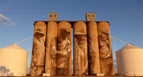
Guido van Helten’s iconic Brim mural was the first silo artwork to appear in Victoria, and soon infused the town’s community with newfound energy and optimism. After gaining widespread local and international attention, Brim’s silo art success shone a spotlight on the Wimmera Mallee region and inspired the establishment of the Silo Art Trail.
Brim is home to Redda's Park, a bushland setting with amenities, walking tracks, powered and non-powered camping sites as well as BBQ facilities. It is the perfect place for a relaxing and affordable escape from the hustle and bustle.